quinta-feira, 29 de setembro de 2022

Fjords experience

         This time, I’ve been during a full summer season at the Norwegian fjords, more specifically at the small village of Geiranger, working as a kayak guide and exploring the surroundings on my free time. Here is a short summary about my experiences and impressions around the incredible scenario of the Geiranger Fjord…

Geiranger (means: ‘arrow shaped fjord’) is a small village of some 150 people in the winter/500 people in the summer (due to the affluence of seasonal workers) located at the very end of the 16 km long (and 250 meters deep) Geiranger fjord, the last branch of the 100 km long Sunnylvsfjord that penetrates the land by Ålesund. The protected area that includes the village of Geiranger, the Geiranger fjord and the mountains to the north of it (and part of the Norddalsfjord) was declared Unesco’s natural patrimony (one of 15) in 2005 for its intrinsic value to humankind.

Location: north of the glaciers of the Jotunheimen National Park; 100 km east of Ålesund (nearest airport); 650 km north of Bergen; 8 hours’ drive to the northwest of Oslo.

What to do: besides running the fjord on a kayak (better than on a rib boat or a ferry boat) to see the waterfalls (the big 3 are: ‘7 sisters’; ‘Suttor’ and ‘Bringa’) or drive up to the Flydalsjuvet (4 km up the east road) or the Dalsniba (21 km up the east road) viewpoints, the most popular activities are hiking and tasting the local specialties: beer; chocolate; moose burger. Other possibilities lay at 45 km (north-east), with the impressive zig zag road or Trollstigen, offering great views and hike opportunities; at 87 km (north-east), by the Åndalsnes town, with hiking trails and a famous ridge; at 50 km (south), with the Stryn summer ski resort (open mid-June and July), or (at 65 km) the town of Stryn itself, and Loen (some 11 km more), with its skywalk (gondola to a peak with views to the glaciers) and daring Ragnar via-ferrata… Other ideas might arise from watching my 5 minutes video on UTube: https://youtu.be/sJpMznGllDw

Highlights: the ‘7 sisters’ waterfall, an amazing fall from 410 meters high that splits into seven fingers; the Dalsniba viewpoint, the highest road in Scandinavia with a view to a fjord, and what a view! You can drive directly there but have to pay around 25€ for the last 5 km (not payable if walking or biking); Zipline course (one hour of family accessible via-ferrata and zipline course that goes next/over a water fall).

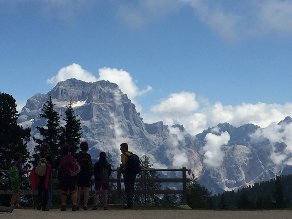
Hiking: mountains around here are not very high (varying from around 1.300 to 1.700 meters high) but, as one starts most hikes almost around the sea level, the accumulated height gain is quite high. So, before coming here, you better train a lot by walking upstairs… The Information/Ticket Office in front of the port will tell you the several options (opens from 9-17h00). There is also a big and detailed map right in front of the UNESCO Fjord Center (opposite to the Union Hotel), on the upper part of the village. One of the most popular trails is called Storsaeterfossen (‘fossen’ means: waterfall) and it will take you about over one hour uphill to reach a waterfall where you can walk behind the drop. Take seriously the marks for each trail (blue is easy; red is hard; black is very hard or technical): if you are not experienced, even the ‘easy’ trails could turn to be a hard surprise. Norwegians in general are very use to hiking therefore their ‘measures’ might not apply to people not use to steep and irregular trails. Also, the trails are very poorly (or not at all) maintained, meaning that you will probably find very wet, muddy and stony trails that require good foot wear, attention and security in moving on slippery and irregular ground; and sometimes the marks (usually a red ‘V’ painted on rocks) will be missing when you most need them (especially closer to the summits). Most of the shorter trails are never circular which is a shame because one needs to walk back on the same trail (for the longer trails there are more options but you need to organize logistics to be dropped off or picked up). A good alternative for smoother hikes with also some nice views lies around the lake Kilstivatnet (‘vatnet’ means: lake), close to the village of Eisdal, 25 km to the north of Geiranger.

Impressions: some described those landscapes as the ‘tropic forest of the north’, as the ‘wet paradise’ or as a ‘Switzerland on steroids’, not that the Swiss mountains are smaller but in a way that the fjord landscape is more dramatic with the steep and dark rock faces falling straight down on the water at sea level.

Some say the Norwegians try to get money ‘from under the stones’, meaning they are charging for everything and too much (on a ferry tour they were charging the same price to a months old baby as to an adult!). This applies in Geiranger, like the toll for the last 5 km on the Dalsniba road, but also to the exaggerated number of tolls on roads that are not highways nor fast roads (E06 and E136) and you need to drive through to get there.

If you spend time enough in Geiranger you will get to know that all the businesses in the village belong to the same five families, in a tight and weird contact web that seems to rule and govern as an oligarchy, and perhaps explains why the local mentality is so closed to outsiders (a foreign business will have a hard time to settle or even start) if it wasn’t for the majority of foreigners (outside workers).

Prices: at the supermarket? Just crazy (there is only one supermarket in Geiranger, the ‘Joker’) … Take a lot of your own food if possible! Prices in Norway, in general, are high, but in Geiranger they are higher! The tours on the sightseeing ferries are also overrated (not good value for the money).

Secrets: the moose burger with french fries at Brygg (next to the bakery, at the village walking zone); vegetarian options also available;  alternatively you can drive to the mountain hotel ‘Høyfjells’ at Grotli (37 km direction east) and get a better deal there. The restaurant Posten is very good too (they have a salmon burger) but very expensive. Try the local ‘Geiranger beer’ with blue berries (costs around 5€ a bottle at Joker) and get informed about the story behind it (lady Bringa brewed it first like that, in the early 1900). My favorite of the 5 sorts was the ‘pale ale’. Try also the ‘Geiranger Sjokolade’, the local chocolate factory (own production) with a cozy terrace located on the walking street.

Stay: at the amazing Grande Hotel (also the more expensive but not better Hotel Union); many cabins/huts possibilities available (being the best located, probably, the ones belonging to the coffee place Hole (3 km higher up the village); two camping sites (one at the water front and the other higher up, next to a water fall). Book any of these quite in advance if going on the high season (July-August).

         Weather: generally rainy! When the sun comes out it can get really warm (even inviting to jump in lakes or the fjord). Average temperature in July is 14º C! Get informed on the forecast (www.yr.no) but even that is not always as accurate as desired. Norwegians have a lapidary ‘saying’, though: there is no bad weather, just bad clothes!

         When to go: to see the waterfalls, better to go in June, when those still carry a strong volume of water and the mountain tops are still covered by a white snow cap; to hike, better end of August/beginning September, when there are more chances of the rain water to drain and the terrains to get less wet. But, of course, Norway is Norway and the weather is never stable or to be trusted. Because of that (I got light snowfall in August, at 1600 meters high), and remembering that ‘saying’, good mountain boots and good trousers and rain jacket are a must on any hike and, just in case, don’t forget to take in your covered backpack spare woolen socks (even more than one pair), gloves, fleece hat/beanie, and buff.

         Have a nice trip and be lucky with the weather!

Video (5'34'') ‘Geiranger-Nw Best Mmts’: https://youtu.be/sJpMznGllDw

Musics in this video: Beautiful world in existence (beggining); ‘She began to lie’, General’s daughter movie (min. 1’09); ‘Equipa de resgate’ música de fundo do video editor (min. 2’01 and 3’17); ‘Raising Arizona’, Carter Burwell (min. 2’45); ‘Espelho d’Água’ música de fundo do video editor (min. 4’04); ‘Explorador’ música de fundo do video editor (min. 4’40);

10 Photos below – Geiranger Fjord:


quarta-feira, 9 de setembro de 2020

Sweden outdoors

As the few followers of this blog know, and the occasional visitor might guess, I post very little articles about traveling and adventures at cities and other crowded spots. My information and images go essentially about active outdoors, challenges, and not so famous and achievable spots. This time I will write you down a few possibilities for activities in the south of Sweden. The north is another thing! (One story including a biking passage through Lapland, ‘Arctic summits – Scandi Peaks 2017’, on this blog, at http://aventuraaomaximo.blogspot.com/2017/07/arctic-summits.html este artigo encontra-se também em Português –, plus a 32’’ video, https://youtu.be/JM-AHswT1TA).      

      One teacher from the Estoril University of Tourism (ESHTE) once interviewed me in order to write her essay on ‘sorts of travelers’. I told her I do not go for package holidays or for the number of countries visited. What I look for are deeper experiences in certain countries, that can bring together some intrinsic cultural (gastronomy, trends, traditions, uses…) aspects, and some geographical secrets (or iconic spots) of that specific country or people, with some form of physical expression (sport).

     As you might have read on my last article, after crossing Europe from Granada (Spain) to Sweden, I have reached the city of Värnamo (south central province of Småland), more or less at the same distance from Malmö and Götenborg but not on the coast. You might wonder, what is there special in Värnamo!?! Nothing particular really..., and everything! The surroundings offer numerous possibilities, scarce population density, green everywhere, and a lot of water…

        In this case (the center south of Sweden), I went there more than once to be able to explore deeply their uses and landscapes… Having available a little cottage outside the small city of Värnamo, to use as my ‘base camp’ and deepen my Scandinavian experience, I have dedicated myself to hike in National Parks, bike around lakes, kayak on, across and around lakes, rivers and islands, and swimming in lakes.

        On the following video you will watch images of:

-      2 days biking around lake Bolmen (150 km)

-      Different activities around lake Vidöstern

-      13 days crossing the Göta Kanal (450 km)

-      3 days kayaking among the Sankt Anna islands (60 km)

-      Swimming across lake Vidöstern (3 km)

-      2 days biking around lake Ånen (93 km)

-      Down Lagan river (64 km)

       On the following texts you will find some short and useful information about each activity:

The first activity has spectacular paths for bikers and hikers only around the south part of the lake. Although your are surrounded by fresh water, tours here could actually lead you to a water supply problem, if you are not willing to drink the lake water with a certain color (the water is drinkable but is heavy on iron), because this is not the kind of country where you’ll find a café-restaurant-store just around the corner (like in South Europe)! To overnight I found a little spot by the lake Unnen (east of Bolmen lake) but you will find a real and simple camping site on the town of Bolmen (normally one is not allowed to camp on the beaches, or badplats, by the lake, but there is not much control either). The real distance around the lake is around 110 km (I did some more because I’ve started and finished close to Värnamo).

Since I’ve mentioned the ‘problem’ of the water, have in mind that the weather will be your biggest issue. The weather is quite unpredictable in Scandinavia and forecasts are never too accurate. However, it is more stable in the summer months of July and August (although in July 2020 it was pure crap). But July is the holiday month by excellence, so, choose August but wait until the 10th because that is when school season (semester) starts, and avoid weekends. Anyway, as the Swedes say, «there is no ‘bad weather’, there is only good and bad protection clothing».

As for ‘Different activities’ around Värnamo and the lake Vidöstern, if you extend the radius of action to a 35 km range, you will find many small lakes to jump in; many small roads and trails for easy mountain biking; a few big lakes to kayak on; the Store Mosse National Park, the largest bog area south of Lapland and one of the most significant National Parks (one of the 30 in Sweden), for hiking (there are several small trails for a couple of hours walks, a 12 km trail around a lake, and a 40 km long trail connecting Store Mosse to Hestra town), bird watching, berries (raspberries, blueberries, lingonberries) and mushroom (kantareller) picking – make sure you know which are the real ones…

The Göta Kanal crossing by kayak, in 13 days, was quite a great experience! The mega construction (is still considered the ‘Swedish Construction of the Millennium’) stretches for 452 kilometers, from the Baltic sea to the Kattergatt sea, or, the same is to say, from Stockholm to Gothenburg, allowing to navigate between the two cities (in fact from Mem, some 80 km south of Stockholm) and opposite coasts across Sweden. The water way crosses seven lakes (Asplängen, Roxen, Boren, Vattern, Bottensjön, Viken, and Vännern, the biggest of Sweden and the third biggest of Europe), one river (Göta älv, 93 km long), and the canal itself, measuring 190 kilometers long and passing 58 locks, connecting all the of them. Of course, one can choose to navigate in only a few sections, or on some lakes (July and beginning of August is to avoid since there will be more boats using it). More about the Göta Kanal and my east-west crossing on my article http://aventuraaomaximo.blogspot.com/2019/09/from-baltic-to-kattergatt-sea-sweden.html (includes a 6’35’’ video: ‘Sweden crossing’ https://youtu.be/Llon1LaYwZA).

Now, navigating among the Sankt Anna islands?! That is an absolute must for any kayak lover! But you must be warned that it is quite easy to get confused and lost in such labyrinth from the low perspective of a kayaker. Although the few existing kayak rentals will provide you with maps and a list of local contacts that include a ‘taxi kayak’ (and on the bigger islands there are always a few residents), the best is to take your own App or GPS – take an objective and let your self get lost in that direction, and then look for your position on the gps to make corrections on your route (rather then trying to follow the islands by looking constantly at your paper map). I’ve paddled with my companion and 2 dogs on an adequately long and spacious kayak for 2 and half days, covering a total distance of some 60 km. We started one afternoon at Mon (on the island of Yxnö, some 30 km east of Söderkoping), where you will find a camping site, a restaurant, and a kayak rental; headed north-east for 2 hours and found a nice place to rest and swim near the big island of Aspöja. The second day we paddled all the east ring of small islands direction south, to the Missjö group. On the third day we passed close to Tyrislöt (same big island as Mon) and made our way north, passing by the big islands of Vänsö and Kallsö before returning to Mon. Important to remember that most of this area is a protected environment and, due to bird reproduction, the access to some of the small islands will be restricted during part or all July (total interdiction means it’s necessary to keep a 100 meteres distance to such designated islands). In August take some mosquito protection. Kayak rentals exist both in Mon and Tyrislöt. (3’30’’ video, dedicado aos companheiros António C. M. e Rodrigo V. M.: ‘Islands Sankt Anna’ https://youtu.be/OnwAvyq-cdg).

     Swimming across lake Vidöstern is an interesting challenge after having a sequence of warm days leaving the water temperature quite confortable, and if one is able to choose a day with no wind, to get the water surface as flat as a ‘mirror’. There is an annual competition in this lake, taking place in August (canceled this year due to Covid19), that covers the swimming distances of 5 and 10 km parallel to the east bank, from north (city of Värnamo) to south, but you can choose crossing the lake east-west (or v.v.) in many spots, being the average width of the lake around 2 km, and never more than 3 km (you will find a badplats or small peers to start and finish, on both sides).

The lake Åsnen is another beautiful scenario for biking. It almost divides in two different lakes because of the many islands and peninsulas in the middle of it. The shortest round, I’ve calculated, must be of around 80 km. Mine was 93 km long: going south from Huseby, through the west bank, and north through the middle section, because this way you are most of the time close to the water. There are a few camp sites and a couple of natural resting areas to overnight. If you choose to go all around you will loose the middle section and you will get away from the waterside (on the east side); If you decide to use all the trails, than the tour could stretch to almost 180 km, but again the east bank is less interesting and you will end up biking twice on a same section. Of course, I had a bit of a logistical problem so my bike tour was in fact of 260 km (170 to get to Huseby and back, from Värnamo). (Full video 'Around Åsnen', 2’01’’: https://youtu.be/AznbldcRPKs)

Down Lagan river. The Lagan river (244 km long) borns on lake Tahesjön, a few km south of Jönköping, goes southwards, crosses the town of Värnamo, drops into the Vidöstern lake and keeps flowing south until the city of Ljunby, later on it turns west and flows all the way to the coast line, having its mouth just south of Halmstad (an area with some of the best beaches). It has a few passages where you will have to carry your kayak around obstacles such as electric power plants: I found 3 on the 64 km between the little lake north of Värnamo and the town of Ljungby (after Ljungby there are another 12). Passing the town of Lagan, with 2 lockers, is better to carry your kayak straight to the south part of it (some 500 meters), or you will have to drag it on rocks. (Full video 'Down Lagan river', 5’55’’: https://youtu.be/b3MBWjKwJGE)

Enjoy!

Video (8'52'') ‘Sweden outdoors’: https://youtu.be/sLrgezCFW10

        Photos below:


terça-feira, 4 de agosto de 2020

Europe crossing: what to do during a 10 days road trip…

If you decide to cross the whole Europe on your car/van, for whatever reason, these are a few things you can do and visit, on a wild mood and outside the big cities.

I had to cross Europe from the Iberian Peninsula to Scandinavia a couple of times, both south-north and north-south directions, being my reasons not important for the purpose of this report. On my last crossing of the continent (July 2020) me and my partner, accompanied by two dogs, decided to take some extra time to add a bit of excitement and make this long trip worth and less tiring. We’ve connected Granada, in the south of Spain (a city with surroundings worth an experience by itself), to Värnamo, in the Swedish province of Småland, where one can find enough lakes, wild forests and bicycle trails that could justify a visit for some active holidays. If the shortest distance between those starting and arrival points is, normally, 3.500 kilometers, possible to cover in 3 days, this time, with a few detours and a 10 days trip, we have covered around 4.600 km.

Here is how we did it…

From Granada, via Teruel and Zaragoza, we drove to/stopped for a few days at Val d’Aran, in the Pyrenees, bordering Aragon and Cataluña provinces with the south of France. There, we camped in the small village of Arties, took a few hiking trails near the ski resort of Baqueira-Beret, and jumped in the cold waters of the little lake d’Aiguamòg. If you are fit for climbing, you can start straight from Arties and test yourself on the iconic peak of Montado, 2833 meters high, or hike the trails to Salardú behind which you’ll find a challenging via ferrata. The touristic town of Viella was quite busy (despite the Covid19 crises) so we avoided it. Alternatively you can also drive the panoramic road to Sort; or choose the valley of Ainsa-Bielsa for wonderful hikes and mountain climbs; or even the Benasque valley – only take into account that the last one has no connection to France and the Bielsa one has it but the road on the French side gets pretty steep downhill and leads to no major road right away. Recommended in Arties: the pizzeria ‘La Oca’; as a curiosity, there are two very small spring pools, on the other side of the river from the camping site (a 10 minute walk and a cost of 3 Euros pp).

Passing the Pyrenees, we used some side roads to get to the highway of Toulouse and, passing the medieval town (UNESCO site) of Carcassone, we got to Narbone and use the highways of the whole south coast of France to reach Italy. Remember never to drive in the south of France near the 15th and 31st of July (or 1st, 15th and 31st of August), because that is where all the French will go! We only found very busy roads near to Nice-Monaco. Arriving at the Ligurian province of Italy we found the first traffic jams due to road works and just had time to look for the first camping in Ventimiglia, by the beach. Camping sites by the beach are absolutely not recommended in the summer, especially in Italy (they are crowded and even the prices are higher than in France or Spain). Having overcome the slight inconvenience we crossed Italy from west to east, direction Rimini (highways A21, A1, A14, to Alessandria, Parma, Modena, Bologna, Imola), on the Adriatic Sea. Close to it there was a special rendez-vouz awaiting for me: the Gran Titano hill, a cliff 739 meters high, in the mini Republic of San Marino, on the top of which there is a three tower fortress which original core is older than the year 1253. This detour to the curiously announced as the ‘terra dela libertá’, forced us to drive around some extra 900 km, totally not worthwhile if you don’t have to. At the RSM they have only one camping, with a very good location (away from noise) and facilities (dog friendly), but quite expensive compared to others. Gasoline, though, is cheaper in RSM. After this quick stop-over we’ve continued north, to the Alps. That night we found a camping on a lido somewhere between Rimini and Ravena, but then again camp sites by the beach are not recommended in the summer!

The Dolomites were the second highlight of this trip, and there we went passing by Venezia and Belluno. In Cortina d’Ampezzo we found the most worth camp site (Camping Dolomiti) and stayed for 3 nights using it as the base for our daily hikes. One of them took us to the Aial lake and further up to the Federà lake (2050 meters), on a very interesting circular route of 6 hours (we only found people by the rifugio Croda da Lago, coming from other directions). The possibilities are infinite and you can dare to walk down to other valleys and get a bus back. On the other days we strolled around Cortina, tried their ice-creams and pizzas (these were not better than the ones of the Pyrenees!), and hiked on the east mountain blocks (from the river Boite) where you can reach the plateau of the Faloria gondola, or dare on the via ferrata ‘Club ski 18’. You can also drive to many other trail heads and start hiking from there. If you come here, plan your hikes in advance otherwise you will feel overwhelmed with so many choices. We regretted having to leave and will want to come back in the future.

Back on our way to the north, we admired the views of the Tre Cima di Lavaredo and other peaks, and the lakes of Landro and Dobbiaco, as we saw many bikers along the smooth trails of the Rienza river. We could’ve taken the road to Innsbruck, straighter and shorter, but instead, reaching the town of Dobbiaco, we went east, admiring the whole valley of the river Drava (or Drau), stretching all the way across the Austrian border and into the town of Lienz, surprised and excited by its innumerous possibilities of trails, peaks, and mountain resorts. We wanted to drive the Grossglockner road!

The iconic road starts to go uphill short after you pass the bucolic village of Heiligenblut, where you get the first views of the highest peak in Austria (Grossglockner, almost 4.000 meters high), hiding right behind the pointy church tower as you enter the village. The simple camping site on a smooth green lawn is inviting but the weather is good and we keep going up. The toll to drive on the road reaching a pass at more than 2.500 meters high (closed from November to May) is not cheap: 37 Euros! As the last bit of the road to the Kaiser-Franz-Josefs-Höhe viewpoint (2.370m) is packed, we decide to park by the Alpinvereinhaus Restaurant (at 2.131m) and walk down the hill, cross the dam that holds the Speicher Margaritze lake, walk up on the other side until you have the magnificent views of the Pasterze glacier. There we had our pic-nic before heading to the pass… The traffic was intense, a lot cabriolets showing off, many cyclists challenging themselves… and then there was an accident (apparently one motorcycle and one road bicycle collided) and it took us some time down the curvy road, to arrive at Zell am See.

There are 3 main camping sites around the lake Zeller, and alternatives by Kaprun (access to the ski resort opened in the summer). The first one was full and we ended at the Panoramic Camping. After settling in we ran to the almost crowded beach on the lake side for a deserved swim. That evening, a sudden summer storm came down on the camping but it went away as fast as it came. The weather was unstable so we skipped the hikes to the top of the Hundstein (2.117m, the highest around the lake) and the Imbachhorn (2.470m, by the entrance of the Kaprun valley). Zell am See was once a highlight but this time it was bit too full for our taste, so we did not stay longer. Instead, we continued north, looking for surprises on the German Alps. Several possibilities were presented to us right around the corner, among which: river rafting in Lofer, just before the border; or hiking/climbing the second highest of Germany (Watzmann, 2.713m), in the Berchtesgaden National Park. Don’t forget to fill your gas tank before leaving Austria: the price is the cheapest we’ve seen (cheaper than in Spain). Again we had intense traffic across the border, due to road works, but we arrived at the Chiemsee lake on time for a nice swim and lunch. Passing Munich we finished the day on a camping site (Azzur campingpark) in Ingoldstadt, on time for a beer and another last swim on the Auwaldsee little lake, right next to our tent.

To arrive in Sweden you can either drive straight north through Leipzig, Berlin and Rostock and take a 6 hours ferry to Trelleborg (or 8-10 to Malmö), in which case you should stop at the white sand beaches of the Peninsula Skanör Falsterbo, where you might be lucky enough to spot some seals; or drive through Magdeburg, Hannover, Hamburg, Lübeck and Fehman island, where the ferry from Puttgarten takes you to Denmark in only 45 minutes (costs some 115 Euros for car + 2 persons, but the Öresund bridge, connecting Copenhagen-Malmö, will cost some extra 60 Euros). If you have some time left, you might want to drive from Munich to Frankfurt, cross to Belgium (back to the Ruhr area through Aachen) and visit the Signal du Botrange, the highest point of the country, on a 694 meters high plateau, around which you will find nice trails both for hiking or mountain biking. To get there, coming from Luxemburg (south), you will drive on bucolic roads between St. Vith and Malmédy, and find small lakes (like the Lac Robertville) and hided castles. 

Once in Värnamo (after crossing the Ostsee, the Danish islands, and driving 2 hours north from the city of Malmö) you might want to visit Store Mosse, the largest bog area south of Lapland and one of the most significant National Parks (there are 30 in Sweden). Store Mosse is rich in bird life and, not just there but through the whole province, you might be lucky to find and pick big and juicy raspberries, blueberries, lingonberries, and also kantareller (eatable mushrooms that cost fortunes in the markets).

See more photos and a short video bellow, and… enjoy the ride!

Previous articles & photos of adventures on this blog: Aventuras literárias de José Tavares; Balkans: several in one…; Climb Mount Fuji; Short video of the Paraguaçu’s Atlantic crossing; The Annapurna circuit is moribund!; From the Baltic to the Kattergatt sea, by kayak; Around Menorca by kayak; Inverno duro, viagens de meia estação!; Next Challenges, 2019; Europa summits – ‘The highest peak of every European country’; Arctic summits – ‘Scandi Peaks 2017’; Greenland crossing 2017 (and Iceland); Iran – Caucasus 2016 – What they don’t tell you on blogs about Iran and the Caucasus; South America trails 2015 – part 1/2; South America trails 2015 – my route – part 2/2; From Ararat to Athos: 3.000 km across Turkey on a bicycle; Crónicas viageiras… nos Balcãs; ‘Ensaio sobre a Solidão’; Esquiar a 8 mil metros e remar no Atlântico…; Os novos exploradores e a aventura dos sentidos; Crónicas de glaciares - ‘Noruega II’; Preparação para a grande Travessia; Crónicas da Noruega I; 3 Peaks Challenge; Novas; Liquidação Total; Périplo maltês; Voltas ao Mundo; Novos livros a caminho…; Horizonte branco II; Horizonte branco – passagens do meu diário de expedição no Alasca…; Ambientes monótonos para escapar … da monotonía!?!; Fim do projecto Ice Care… ; Boa, João!; Pausa nas aventuras…; Mulheres Aventureiras I; Mulheres Aventureiras II; Viajantes e protagonistas…; Ice Care #2, a Partida…; No capítulo ‘Desporto de intervenção’…; Hora de responsabilidade…; 350 …; Aventura ao Máximo – errata; Alterações climáticas e eficiência energética; Viajar e encontrar-se…; Vulcões de Auvergne; Glaciares em agonia; Ice Care in Switzerland; Portugal Bike Tour 09; Trecho do novo livro ‘Os Novos Exploradores e a Aventura dos Sentidos’; A publicação de ‘Aventura ao Máximo’; …

Photos:
Val d'Aran
Montado peak
Camping Arties
Republica San Marino
Dolimites
Cortina d'Ampezzo
Cortina d'Ampezzo
Camping Dolimites
Lake Fedèra, 2046m
Refugio by the lake Fedèra
hiking Dolomites
hiking Dolomites
hiking Dolomites
Cortina d'Ampezzo
Heiligenblut by Grossglockner
Ingoldstadt
Camping Ingoldstadt

lake Aiguamòg, Val d'Aran
canine companions in the Dolomites
lake Fedèra, Dolomites
castle by Malmédy, Belgium
 Östersund bridge Denmark-Sweden

Video (1'33''):
or